


The ministry undertakes various publicity measures and awareness campaigns on road safety through social media, electronic media, and print media. It also provides financial assistance to NGOs, academic institutions, and trusts for road safety advocacy and offers awards for outstanding work conducted in the field.15
India’s vast network of highways serves as a lifeline for the country’s connectivity and economic growth. While a considerable amount of work has been done to increase the safety and efficiency of the highways, there is room for improvement. Devayan Dey, Dibyendu Sengupta and Trishul Palekar propose forward-thinking solutions to address these gaps.
Figure 1: Existing condition – A highway without a deceleration lane
0:30
Figure 1: Present condition – A highway without a
It’s a common enough occurrence on India’s highways. As the leading vehicle decelerates to exit, the following vehicle, which does not intend to exit, is forced to slow down, usually without due warning, thus increasing the possibility of a rear-end collision. This could be resolved with a simple tweak in the design of our roads.
Figure 2: Proposed design – A highway with a deceleration lane
0:16
Figure 2: Proposed design – A highway with a deceleration
With a dedicated deceleration lane on the highway, vehicles can use the speed change lane to exit. This would eliminate the need for the vehicles following them to slow down, thereby minimising collision risk.
Driving growth: India’s expanding highway network
India’s rapid strides towards developing a vast national highway network along with various infrastructure-focussed initiatives have been vital in facilitating economic growth and connectivity, and various key initiatives have been taken in the last few years to strengthen this network.
The country has launched the Bharatmala Pariyojana, a network of economic corridors with feeder routes for facilitating freight traffic across 83,677 km of road network to be constructed within five years.1 The implementation of FASTag – a cashless toll collection system as part of the Bharatmala Pariyojana – is also meant to upgrade the nation’s transport system. The National Infrastructure Pipeline,2 a first-of-its-kind government exercise, is meant to provide world-class infrastructure to its citizens while the Gati Shakti scheme will help establish multimodal connectivity for more than 1,200 industrial clusters.3
While these initiatives are commendable, safety remains a pressing concern for India’s highway network. National highways contribute to 31% of road crashes and 36% of road fatalities in the country.4
Figure 3: Road crashes, fatalities and injuries on the national highways
| Year | Number of crashes |
Deaths | Injuries |
| 2017 | 1,41,466 |
53,181 |
1,42,622 |
| 2018 | 1,40,843 |
54,046 |
1,40,622 |
| 2019 | 1,37,191 |
53,872 |
1,37,549 |
| 2020 | 1,16,496 |
47,984 |
1,09,898 |
| 2021 | 1,28,825 |
56,007 |
1,17,765 |
Source: Road Accidents in India - 2021
To enhance road traffic safety, focusing on the finer elements of transportation infrastructure is as important as the expansion of the network. These could include features such as:
- clear signage including regulatory (mandatory), warning, guide, information, and work zone signage to match the category of roads they’re installed on,
- minimisation of junction conflicts so as to reduce a potential crash and its severity,
- channelisation to regulate conflicting traffic movements and prevent wrong turns/exits, and
- smarter designs and design standardisation which reduce the risks taken while violating traffic rules (e.g., wrong way driving).
Often such features can help enhance the travel experience on the highways, ensuring both safety and comfort.
This article analyses existing highway designs, reviews international best practices and, in consultation with experts, provides recommendations for three deficiencies in national highways in India that have a direct causal relationship with collisions and the level of service offered on Indian highways.
Areas of concern in the current highway design
Auxiliary lanes are designed to create a dedicated space to manage speed differentials between a vehicle exiting or entering the highway and a vehicle travelling through the highway. In the context of India’s national highways, two types of auxiliary lanes are most relevant:
- Deceleration lanes: Deceleration lanes are short sections of additional lanes built to allow drivers to slow down before exiting the highway. They are critical for safe and efficient exit of vehicles from the highway. The deceleration lane enhances safety and efficiency by creating a separate space for decelerating, thus preventing rear end collisions between decelerating vehicles and accelerating vehicles on the main carriageway (figure 2).
- Acceleration lanes: Acceleration lanes allow drivers to speed up before merging with the main highway traffic. Figure 4 depicts a highway without an acceleration lane. As the leading vehicle accelerates after entering the highway, the following vehicle is forced to decelerate creating the possibility of a rear-end collision. Figure 5 depicts the same scenario but with an acceleration lane. The acceleration lane reduces the speed differential between the leading and following vehicles, thus reducing the probability of a rear-end crash.
Figure 4
0:30
Figure 4
Figure 5
0:27
Figure 5
- The need to shift gear: Unfortunately, many national highways in the country lack acceleration and deceleration lanes. This is in spite of the Indian Roads Congress (IRC) emphasising the need for speed change lanes and laying down the design for these lanes in its guidelines. According to the IRC, if the recommended full length of deceleration lane is not feasible, even sub-standard lengths can be of benefit but they should not be less than half the recommended lengths.5 Figure 6 shows the recommended design for auxiliary lanes.
Figure 6

Such design features are desirable since they are backed by the governing design codes. Their absence is often explained by lack of right-of-way or land acquisition issues due to which there is little or no space for road expansion. But the same issues surface even in greenfield highways that are built from scratch even though, in these instances, it is possible to account for land acquisition to factor in speed change lanes at the design and planning phase itself.
According to experienced lead highway design engineers, one reason for the absence of acceleration and deceleration lanes is inadequate information on the reference design provided to the contractor. Contractors are usually provided with typical cross sections without detailed designs for junctions that are customised for every location. This leaves the design open to multiple interpretations.
The awareness of the drivers and their behaviour is another aspect which needs to be tackled. Often, drivers tend to use auxiliary lanes to speed up instead of using them for diverging, merging or weaving manoeuvres, thus impacting the intended functionality of speed change lanes. Rigorous ticketing and enforcement of challans can help monitor and curb such violations.
Service lanes are short roads which run parallel to the main highway and are used for local traffic. They are critical for providing access to local businesses and houses along the highway. However, when it comes to service lanes, there is often a lack of clarity on whether they are two-way or one-way streets. This lack of information can lead to chaos, gridlock, friction on the main highway, and even crashes, especially during peak hours. Figure 7 illustrates this problem.
To address this challenge, it is essential to provide clear guidelines on the use of service lanes and ensure that they operate safely and efficiently.
Figure 7

Directional dilemma for drivers
The IRC guidelines require service roads to operate as one-way facilities. The IRC codes that apply to signage clearly recommend the installation of ‘Do not enter’ signs at the junction of service roads and cross streets.6 The IRC also prescribes installation of ‘No Entry’ signs at major junctions,7 however, this too does not mandatorily reflect in practice. All service roads therefore operate as two-way facilities leading to the creation of dangerous acute angle intersections at the highway entry/exit junction.
All international design guidelines strongly warn against roads intersecting at a sharp angle of less than 70 degrees to avoid the creation of blind spots.8 Such sharp angles, along with the practice of combining exit/entry points to the highway create intersecting conflicts, particularly when vehicles need to cross paths to access the service road. This violates fundamental highway design principles, leading to blind spots and potentially dangerous conflict points. A conflict point can be defined as a location where the trajectories of vehicles deviate/intersect due to their paths. These conflict points are categorised into four types:
- Merge conflict: This occurs when a vehicle from another lane or another route converges into a lane of another vehicle.
- Diverge conflict: This occurs when a vehicle moves away from its lane to join another lane or to take another route, and hence can slow down and inconvenience the vehicle behind.
- Weave conflict: This is a combination of merge and diverge conflict that happens when vehicles switch from the wrong lane to the correct lane.
- Cross conflict: Cross conflict is a major conflict which occurs when two vehicle paths collide with each other, at right angles, and may lead to a severe road crash.
Figure 8
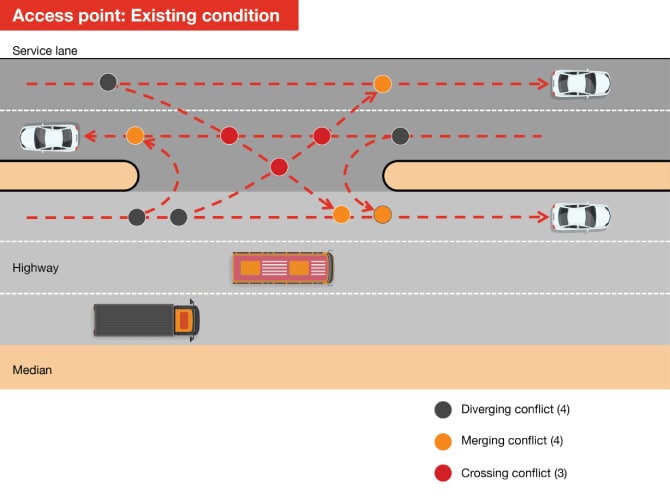
Figure 8 illustrates conflicts that can occur on entry junctions on a highway. In this image, a two-way service lane along with the absence of deceleration and acceleration lanes has led to the creation of 11 conflicts.
Figure 9

In contrast, figure 9 depicts how designing the highways to enable separate entry points drastically reduces the number of conflict points to one.
Figures 10 and 11 show the conflict points as vehicles exit from the highway.
Figure 10
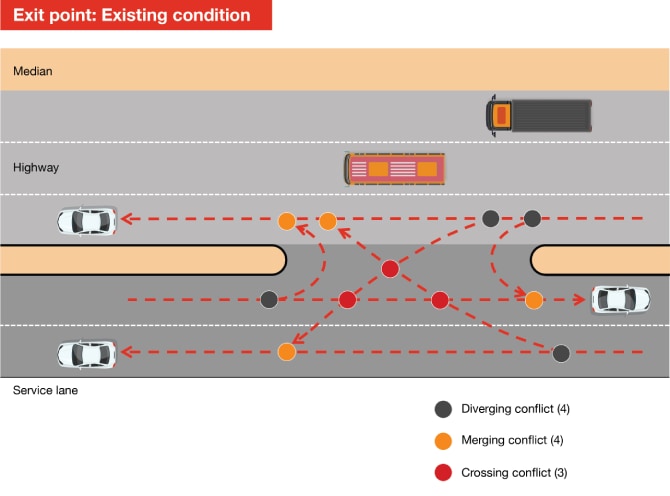
Figure 11

Therefore, it is critical to adequately address areas of conflicts either for interchanges or for entry/exit of service roads at the design stage.
Land use regulations govern how various stretches of land can be utilised or developed. Absence of proper land use regulations along national highways and inadequate enforcement of the law has led to haphazard development that can hamper urban planning and aesthetics. The IRC has dedicated an entire code to highlight the ill effects of ribbon development – the mushrooming of commercial structures and settlements along the newly built highways.
According to the IRC, ‘ribbon development creates ugly and blighted spots where there might have been scenic surroundings.’9 However, loss of aesthetics is not the sole drawback of ribbon development – the surge in local traffic and large pedestrian movement along the carriageway and across it poses a much larger safety risk. Ribbon development can also hamper the widening of a highway in the future as it would require acquisition of costly properties along the highway.10 Encroachment is another interrelated problem with ribbon development. Encroachments are a common sight on service roads and often start as temporary settlements before turning into permanent ones.
Measures to curb ribbon development
National highways should not become tools which support urban sprawl by encouraging such developments. Some of the suggested measures to curb ribbon development are:
- acquisition of adequate highway land that takes future requirements into consideration,
- proper land use regulations with authorities reserving the right to decide how a land abutting on the highway right-of-way is used, and
- laying down restrictions on building height and set-back distances.11
The most significant consequence of ribbon development, however, is the rise of uncontrolled access and exit points. This uncontrolled development and access increases side friction on roads that are meant to be high speed corridors. As a result, habitations develop and multiply over a period of time, resulting in changing layout of the road for small stretches, which makes it difficult to control the operations and safety of these high speed roads in patches. Standard gateway treatments, such as rumble strips, that are proposed to reduce speed and increase safety, do not have much effect. Mere control over the number of access points is also inadequate, as they also need to adhere to geometric standards.12 As per the IRC, if the minimum standards needed for safety are not attainable at a particular location, such access points should be discarded.13
Direct access to properties from new service roads must not be provided. The service road must be constructed only to provide access to and from the highway. Figure 12 illustrates the current state of service roads while the implication of this change is made clear in figure 13. On existing service roads which provide access to existing properties, retrofitting and urban design projects could be undertaken to reduce the width, construct channelising islands and pedestrian infrastructure to streamline the flow of traffic in a unidirectional manner (i.e. one-way movement only).
Figure 12

Figure 13

Our Take
The Ministry of Road Transport and Highways (MoRTH) acknowledges that given the high number of fatalities and crashes, it is necessary to bring about systemic changes in road safety on national highways by all road-owning agencies.14 As observed earlier, the deficiencies in the design of our highways admittedly pose safety risks for drivers and increase traffic disruptions. Therefore, MoRTH has formulated a multipronged strategy to address the issue of road safety based on:
Engineering
Enforcement and emergency care
< Back
< Back
[+] Read More
While ample road crash mitigation measures are in place, larger corrective steps are required to drive real change. Several countries have implemented innovative solutions to enhance safety on their respective highways. It may help to take a leaf out of these global textbooks and adapt some of them to our road safety plans.
Learning from global best practices
- US highways lead with innovative intersection designs
- Highway project development in Europe prioritises public involvement, safety and sustainability
US highways lead with innovative intersection designs
While India has prioritised grade-separated interchanges, also called flyovers, to reduce congestion, the US has been exploring non-traditional intersection geometric treatments to curb conflicts. The implementation of non-traditional design patterns into transportation planning has gained traction in the past few decades as a response to challenges faced by conventional designs. For instance, generally, at conventional intersections, drivers turning left are in the path of the oncoming through traffic from the opposite direction. Alternative intersection designs eliminate this problem. For instance, continuous flow intersections (CFI) – developed in Mexico and adopted widely in the US – have traffic turning left placed to the left of oncoming traffic, opposite to where it normally is.20 Research in the US has shown that this design has reduced traffic congestion significantly compared to conventional intersections.
Another example is the diverging diamond interchange (DDI) originally introduced in France and first opened in the US in 2009. A diverging diamond interchange allows free-flowing turns when entering and exiting an interstate, eliminating the left turn against oncoming traffic. It is easy to navigate, eliminates last-minute lane changes, has few conflict points and provides better sight distance at turns, resulting in fewer crashes.21 Since 2009 over 150 of these types of interchanges are open to traffic in the US with many more under development.22
In several IRC codes, too, detailed specification on design elements such as sight distances, auxiliary lanes, and even roadway-specific sign types and sizes are provided similar to the American Association of State Highway and Transportation Officials (AASHTO), Manual on Uniform Traffic Control Devices (MUTCD), and other roadway design manuals in the US and other countries. According to AASHTO, the width of an auxiliary lane should be equal to the through lanes. Where auxiliary lanes are provided along freeway main lanes, the adjacent shoulder should desirably be eight to 12 feet in width, with a six-feet-wide shoulder being the minimum consideration.23 Having a wider shoulder provides more space for vehicles to safely manoeuvre in case of emergency stop or breakdowns.
Highway project development in Europe prioritises public involvement, safety and sustainability
Countries such as Sweden, Denmark and Germany share some common characteristics with respect to their highway agencies. In each of these countries, a national agency is responsible for developing and maintaining the national motorway system. Each government has given these agencies a safety mandate, with target levels ranging from no fatalities to a 40% reduction in fatalities and serious injuries.24 This focus on safety sets the stage for most actions regarding roadway geometric design and project development. In all these countries, three steps are typically followed in the project development process:
- a project need is identified on the basis of long-term plans or through a political request.
- a feasibility study is conducted to examine alternatives and public input sought.
- a final design is prepared for the project construction and completion.25
Unlike developing countries where a project is envisaged and announced to the public, European countries encourage public participation, even in the initial stages. Furthermore, integrating both human and natural environmental concerns is an integral part of the project development process in these countries.26
Public meetings and work groups are a vital part of project development in Germany. The Swedish National Road Administration has laid down a set of guidelines to be followed during the project development phase, including community planning, transparency (open mindedness and decisions involving the public), environmental concerns, safety, clearly explained decisions, and assurance of public understanding of these decisions.27 The Netherlands also presents all alternatives for a particular project at a public meeting, where the public’s assistance is sought to finalise the best alternative.
Moreover, the highway agencies of these countries are also committed to addressing environmental issues. They rely on local governmental agencies to develop environmental impact studies (EIS) for projects. Highway projects in India, especially those in mountainous regions, often face opposition from local communities due to environmental concerns. Stricter adherence to environmental norms and encouraging community participation can help address and mitigate such concerns in India.
Furthermore, in India, the public at large is often not aware of the finer details of highway development projects except what appear as news articles.
However, involving affected communities along the corridor of development is a common practice as part of the ancillary activities including road safety awareness campaigns and social safeguards processes.
Key recommendations
The following recommendations address the gaps identified in our analysis of national highways and can help achieve significant improvements in terms of safety, traffic flow and efficiency.
Road-owning agencies should subject the highway designing teams to the same scrutiny as chartered accountants or medical professionals. The highway design practice needs to undergo a regulatory change wherein highway engineers ought to be licensed to practice and be held liable for designs that do not follow the prescribed norms. Such practices are already in place for architects and structural engineers. A similar licensing regime could be extended to highway and bridge engineers. mandating licensing will help in ensuring higher standards of professionalism, expertise, ethics and accountability while safeguarding the integrity of the highway network.
Apart from cracking down on the misuse of speed change lanes and enhancing signage on service roads, there is a need to redefine the use of service lanes. As per existing IRC codes, service roads are not allowed on expressways. The challenge lies in the four-lane and six-lane highways which have service roads. In fact, four-lane roads also have the provision of at-grade junctions which pose further safety risks. Highways need to be designed in a manner in which access ramps are the only points connecting arterial roads to the main highway and direct access to highways for at-grade junctions is prohibited by the use of one-directional service roads. Service roads should not provide through traffic connectivity.
This way, through traffic will use the main highway while service roads will cater to local traffic needs. In locations where the existing service roads function as access ramps to the highway and also provide direct connectivity, there is a need for retrofitting. The proposed approach suggests that the service roads should serve as access ramps to the highway but not as routes for continuous through traffic. This can be achieved by adopting innovative urban design, including the reduction of the width of service roads to permit single lane driving. The recommended design principle will lead to a more organised traffic flow on highways by integrating well-designed access ramps and limiting through connectivity on service roads.
Technological advances in the field of highway designing are yet to reach Indian shores where highway design practices are still rooted in paper-based plans. A transformative leap is necessary to embrace 3D corridor design as well as simulation models that involve creating digital representations of highway corridors. Engineers can use 3D models to simulate access ramps, interchanges and intersections to optimise the design and construction of a highway and identify potential conflict points.
There are other advanced 3D modelling solutions that countries in the West have been quick to adopt. For instance, building information modelling (BIM) is used for road infrastructure projects in countries such as the UK and the US. Finland, in fact, is considered a BIM leader in Europe and aims to fully digitise processes in the design, construction and maintenance of infrastructure by 2025.28 Sweden followed Finland’s steps and has emphasised increasing the implementation of BIM at a national level.29 Since 2013, Sweden has used BIM to design and build large and complex projects, such as the Stockholm Bypass, that connects the northern and southern parts of Stockholm. For the Stockholm Bypass, BIM was initially used to visualise and gather information about the project and then utilised to choose methods for development of structures.30 Under BIM, all relevant information about the project was stored in databases and digital 3D models via a shared IT platform to facilitate coordination among several teams.
Digital 3D models also reduced the risk for collision between different construction components.31 This enabled development of a safer structure as potential defects were revealed at an early phase and could be factored in. Thus, using BIM helped the Swedish Transport Administration in reducing cost and time at the planning stage by avoiding bad decisions that would otherwise be discovered only during the construction phase.32 In India, BIM is increasingly being adopted for the Metro rail projects across the country. Therefore, it would be beneficial to adopt it for road design practice as well.
The road ahead
The proposed measures will not only contribute to a more efficient transportation infrastructure, they may also unlock social and economic benefits for the nation. For instance, a solid highway network encourages development of industries along transport routes while a smoother road infrastructure reduces logistics costs for businesses. To ensure transformative outcomes, action rather than mere intent is necessary. For starters, the design template for the highways must be overhauled to ensure smoother transitions and to minimise intersecting conflicts. The number of conflict points is a crucial aspect to consider at a typical intersection. The current design template for service roads often results in a higher number of conflict points, exacerbating congestion and increasing the possibility of road crashes.
By reassessing the design and implementing measures such as dedicated turning lanes, signalised intersections, and roundabouts, road-owning agencies can effectively reduce the number of conflict points and enhance safety at junctions along national highways. Embracing these changes will contribute to the development of a modern and well-functioning transportation network that serves the needs of India's growing population and fosters the country’s economic growth.
Also contributing to this article were Vishnupriya Sengupta, Ruchika Uniyal, Karthikeyan B and Akshit Ahuja
Follow PwC India


Contact us


Mohammad Athar
Partner, Economic Development and Infrastructure, PwC India
Tel: +91 (0) 124 330 6005
